Monday, December 29, 2008
URL address for blogspot RSS Feeds
insert your blog name into the url above and you are good to go.
Thursday, December 25, 2008
Tuesday, December 23, 2008
Monday, December 22, 2008
Visibility Parameters
Found a new way to annotate blocks and facilitate output to databases. Use the visibility parameters on dynamic blocks. This lets you set what is visible vs invisible on the block for whatever parameter you have currently chosen. Use this to display hydrologic group or land use rating (fair,good,poor) for instance. This data can then be extracted, then copied and paste it to the spreadsheet exported map3d attributes (put an attribute in the object data that will be blank upon export, then copy with the land uses).
Sunday, December 21, 2008
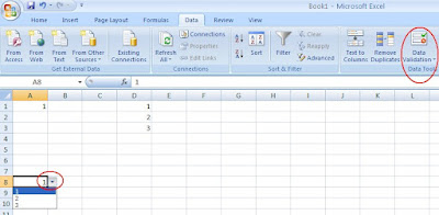
Pull Down Choices for Excel Cells
Monday, November 24, 2008
Analyze Overall Curve Number with Map 3D
There are a number of concepts to understand when using this procedure:
Topologies
Map Cleanup Tools
SHP file import/export
Map Annotative Templates
Object Data
Centroids
Topologies are prepared for each category -- watersheds, hydrologic groups, and land use.
The watersheds are delineated in Civil 3D.
The hydrologic groups topology is made by importing NRCS SHP files for soils. The hydrlogic groups is assigned by a variety of methods. The most simple way is to just enter the group in the object data via the properties toolbar for each polygon.
The land use topology is fashioned the same way as the other three. This topology will also have the uses assigned via the properties toolbar. A visibility dynamic block can help with importing features with a pull down menu. This data is exported with the "dataextraction" command and can be copied and pasted to the shape file of a dbf database.
The topologies are then overlayed. An object data table is created for each subsequent topology for assigned data from the relevant topogies. It helps to have seperate layer assignments for your topology linework, centroids, and annotations.
Two seperate overlays will need to be performed. More later...
Wednesday, November 19, 2008
Friday, November 14, 2008
Thursday, October 23, 2008
Problems deleting annotative objects
Recently, I’ve had trouble deleting annotative text. I’d select it and delete it, to no avail whatsoever. Talked to a co-worker and discovered a workaround – you have to do the audit command, then select no. For some reason or another, this is necessary make the text deletable.
Tuesday, September 23, 2008
Autocad Macro Commands affecting Pickfirst Properties
I had an issue a little while ago my object selection was being canceled by autocad when I initiated a command. I thought maybe my pickfirst had been reset to 0 (causes autocad to ask you to select your objects after your command when 0) because of a crash. I discovered it was set to 1 so that was not the problem.
Then after a little sleuthing, I discovered that the command lines for some of the macro command lines in the Customizable User Interface were prefaced by ^C^C_. This is done in order to cancel out any previously initiated commands that might interfere. However, this also clears your current object selection as well.
To stop this, you need to go into your CUI (type:CUI) and scroll down to the command causing you issues. See the attached image for an example of said prefix in the macro for the properties command. All you need to do is delete it, apply the CUI settings, and hit OK.
You are now good to go.
Monday, September 22, 2008
Dealing with Multiple Surface Boundaries
I’m currently working on a site that has wetlands and numerous boundaries across the surface. I do not want the surface to triangulate between each of these surfaces, so I’m isolating them with boundaries. This has proved tricky in how to define things.
I define an outer boundary with no breakline first. Subqequent boundaries are defined as show with no breaklines either.
Wednesday, September 17, 2008
Monday, September 15, 2008
Show plan view location in relation to profile
Use command showdrawingtips to see your plan view location depicted as you scroll through profile view.
Friday, September 12, 2008
Create polyline from spline
Set Splinetype to 5 instead of 6.
Explode newly created spline.
Use polyline edit PE” command again before anything else, select M for multiple, then P for previous (will select objects from previous command), then do the Join subcommand within PEdit.
You now have a polyline created from a spline.
Wednesday, September 10, 2008
Monday, September 8, 2008
Convert Extracted Surface Points to Civil 3D COGO Points
Use the surface extraction command to bring up the autocad formatted points.
Use the convert autocad points command at the bottom of the points menu to bring up the points to convert.
Change the create points command under the points menu as shown above to avoid having to enter descriptions for each point manually.
Wednesday, August 13, 2008
You Have to Freeze Style Layers
To make a style entity turn off in an xref, you can’t just freeze the layer. An example is for alignment labels. You have to freeze C-ALGN in order to get the alignment line and layer to disappear, you can’t just turn it off.
Thursday, August 7, 2008
Tuesday, August 5, 2008
Making Text Label Lines Not Plot
Put the surface text labels on a text layer correlated with the surface (not C-TOPO-MAJR, etc.). Change the object layer to a very light plot style so it doesn’t so up.
Friday, August 1, 2008
Snapang Command
Change the angle that the ortho mode crosshairs draw and write at by using the snapang command. The crosshair angles are changed but the ucs is not.
Wednesday, July 30, 2008
Hide alignment but show labels
Create alignment entities on C-ALGN.
Don’t freeze or turn off the object layer – FREEZE (not turn off) C-ALGN, and no lines or curves from alignment will show.
You have to have the alignment on in order for the labels to show.
By freezing the entity layer, the alignment is still considered “on”.
Adjust Tool Tip Display
Via right click on the entity (grading, alignment, surface) category under the tool prospector. Adjust under tool tip display setting (yes/no).
Tuesday, July 29, 2008
How to hide alignment but keep labels
Turn off the layer that the alignment entities are on (….C-ALGN),
But NOT the layer that the alignment is on (C-ALGN-****).
Have the labels on a layer separate from the alignment entities (arrows, etc) and put on C-ALGN-TEXT.
Monday, July 21, 2008
CREATING TESSELATED 3DPOLYLINES
Create an arc based feature line using desired elevations. Explode the feature line for a tessellated 3d polyline. Weed the polyline to get rid of undesired excess vertices.
Thursday, July 17, 2008
DELETE EXCESS PROFILE VIEWS THROUGH THE PROSPECTOR
YOU HAVE TO DELETE THEM UNDER ALIGNMENTS > PROFILES IN THE PROSPECTOR – CANNOT DO IT UNDER THE CREATE PROFILE DIALOG BOX


